
BENGALURU: A sharp 1055% rise in
built-up areas
(concrete structures and paved surfaces) in Bengaluru over the last few decades has been well acknowledged. But what has gone unnoticed is the 79% fall in the water spread area, affecting the availability of the precious commodity and 88% loss of
vegetation
impacting the sequestration of respiratory carbon in the last 50 years.
The revelations come amid a severe shortage of water gripping the city, necessitating even its rationing. The startling loss of green cover and the water spread area is part of the recordings documented by Indian Institute of Science (IISc) scientists who have mapped the transformation and evolution of Bengaluru over the last 50 years. Presenting their analysis in a recently released model, the scientists have unveiled a public information system— BuiS (Bangalore Information System) and BLIS (Bangalore Lakes Information System) by making use of free and open-source software to help researchers and policymakers take note of the unplanned urbanization which is taking a toll on its citizens.
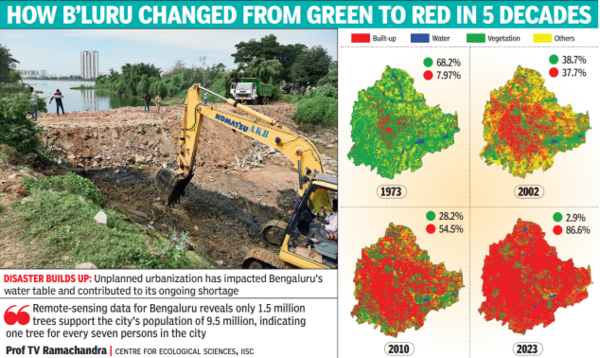
According to Prof TV Ramachandra of IISc’s Centre for Ecological Sciences, the water spread area has plummeted from 2,324 hectares in 1973 to just 696 hectares in 2023 and it is said to be the root cause of the depleting groundwater table across Bengaluru. “The extent of water surface in Bengaluru during 1973 was 2,324 hectares. Over the last 50 years, due to reckless concretization, the water surface has shrunk considerably. Of the remaining water bodies, 98% of lakes are encroached upon and 90% of them are fed with untreated sewage or industrial effluents. Naturally, this has impacted the recharge of the groundwater table as well.
The reduction in water surface area has also affected the groundwater recharge across Bengaluru,” he pointed out. Incidentally, the IT city’s built-up area way back in 1973 was just 8% and it stood at 93.3% in 2023. Ramachanrda attributed the higher quantity of air pollutants and rising temperature levels to a significant loss of the green cover. “Remote sensing data for Bengaluru reveals only 1.5 million trees support Bengaluru’s population of 9.5 million, indicating one tree for every seven persons in the city. However, this is insufficient even to sequester respiratory carbon which is 540-900g per person per day,” he pointed out.
The BUiS, according to researchers, helps all in visualizing the urban dynamics of Bengaluru, ward-wise number of trees and their spatial distribution and lakes or waterbodies. It also helps in visualizing ecologically sensitive regions in Bengaluru. “Unplanned urbanisation, especially over a short period of time, poses serious problems such as pollution, inequitable distribution of natural resources, traffic congestion, spread of slums, unemployment, increased reliance on fossil fuels and uncontrolled outgrowth or sprawl in the periphery,” Ramachandra said. Researchers Bharath H Aithal, Vinay S, Tulika Mondal and Abhishek Baghel have also contributed extensively to setting up the system by collecting historical data.


 English (US) ·